
Investing In New Forests? — How to prove trees have actually been planted.
A blog by Daniel Ronen, a Frontier Tech Hub Implementing Partner.
Read more about Project Sapling’s field trial.
Global attention is increasingly turning to large scale reforestation as a means of mitigating the causes and consequences of climate change and reversing environmental degradation. However, reforestation investment in some areas has historically been hampered by difficulties in verifying and monitoring activity on the ground. This has also been compounded by scandals in the ‘carbon offsetting’ market, see Guardian and LE articles.
So, how can you prove investment in tree planting is actually resulting in ‘trees in the ground’, when verification is so difficult ?
Under the UK Aid Frontier Technologies (FT) programme, a project was established in late 2022 to investigate and trial specific technical innovations to support reforestation verification. The project revolves around two methodologies: (1) local communities becoming custodians of the forest and therefore ensuring its sustainability; (2) reliable and objective web-browser-viewable verification based on data fused from mobile phones and drones of the tree saplings and plantation area respectively. Providing a clear and intuitive verification system to those wishing to invest in reforestation could help unlock additional investment in this sector. For the project, UAVaid partnered with TCS and Crown Agents.
An earlier phase of the project saw drone-mapping tested and evaluated in Cornwall (UK) to assess the technology’s ability to map large areas quickly and efficiently. Read more about this here. Building on the learning produced, our next sprint centered on proving that the data necessary to provide objective verification of reforestation activity could be captured effectively ‘in the field’, even in the most difficult of contexts, using drones and a specialised smartphone app.
The first live field trials occurred in Sierra Leone May 2023, with the objective of deploying and testing the mobile app and drone data capture in extreme remote context(s).
How Remote?
For the tech innovation to be applicable across all contexts, it must be operable in remote areas devoid of modern external infrastructure such as wi-fi and mobile cellular networks. The choice of pilot site needed to reflect this. The site selected was a community in eastern Sierra Leone, just south of the Loma Mountains.

Field test site, Loma Mountains in Sierra Leone. (Artwork credit: www.freevectormaps.com)
This community has a long standing relationship with the project’s local implementation partner, TCS, which greatly facilitated engagement, as explored here.
Travel to the community took 12 hours by Land Cruiser from the capital, Freetown. Unsurprisingly, the journey was less than straightforward and resulted in 50% of the convoy vehicles being stranded at the side of the road en-route from damage.
The road was typical of that found in many remote regions of Africa. We were told that it is impassable in the rainy season, cutting communities off from outside access for months on end by anything other than people on foot or occasional bike.
The Verification Tech — Proving Planting Activity
The verification solution comprises two parts: (1) Data collection (2) Data Fusion and Representation.
Individual Tree Level Data
In order to verify and potentially model a newly planted and growing forest, data about each individual sapling needs to be captured, ideally at the point of planting. This will allow the tracking of the plant’s full life and reduce implementation risks, such as double counting or errors with date records.
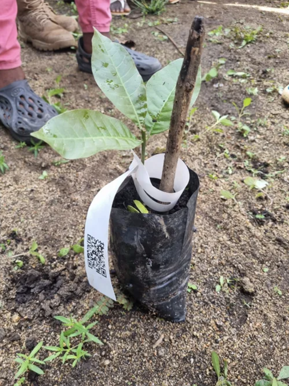
Getting ready for planting. The verification system collects data about each individual sapling.
A research exercise was completed that investigated different existing ‘carbon verification’ standards. This revealed not just differences in the data collected between the different standards, but an opportunity to blend the best of each to create a new standard that is simple, intuitive and comprehensive — to become best in class!! This was distilled to a data requirement for each sapling to include (1) planting date (2) precise location (3) who planted it (4) photographic evidence of the planting (5) species information (6) a unique identifier for the tree.
The App
One of the key innovations of the project is the use of a specialised smartphone ‘app’ to capture key information about each individual sapling as it is being planted. Capturing this data provides evidence of activity (which is then verified and monitored by drone) as well as further downstream analysis. The identified data capture fields (above) were used to provide framework objectives for the developers and coders, who designed the data structure and technical issues such as file formats, data flow and upload compatibility. Crucially, the technical principles to fuse the data from the app, with drone imagery, was established. The decision to develop the app exclusively for the android platform, excluding compatibility with iOS, appears in hindsight to have been a good decision and saved development £cost, as the options for ruggedised smartphones running android are significantly wider and cheaper than iOS.
Field research in an earlier sprint by our implementation partners had shown that both the digital and text literacy levels of people living in remote communities in Sierra Leone varied considerably, even within the same community. Therefore, the app design principle was adopted to minimise the required literacy level of the user to the lowest possible, whilst maintaining product viability. This would mean designing it to be graphically driven, follow a linear process with few ‘options’, and be extremely simple to use. This approach would broaden the potential ‘user base’ and support social inclusion when implementing the system into other communities beyond this pilot. As the design evolved, there was a need to test the interface with the intended users. Unfortunately, communication with the remote community was challenging, hampered by lack of internet, phone and poor road transport links. The decision was therefore made to use the team at TCS as a proxy for the community workers, having built an understanding of local capabilities and capacities through previous projects. Being based closer to Freetown meant that they were ideally located to provide feedback on the app design, virtually. Collaboratively and through an iterative process of consultation, development and refinement, the design was finalised. Further, the technical functionality of the app was tested in different parts of the UK to ensure the GPS tracking and QR code reading worked reliably.
On completion, the app was uploaded onto ruggedized Android mobile smartphones in preparation for field testing in Sierra Leone.

Some screenshot examples showing the graphical nature of the app.
Field Implementation
In a nursery behind the school building, the community prepared 2,000 saplings for planting within the vicinity of the village. Each sapling was individually bagged, supported by a cane or stick, around both of which went a ‘tree tag’ marked with a unique QR code. The tree tags used under this Sapling protocol are long-life and recyclable, with a toughened resin ‘ink’ for the QR code to ensure reliable scanning by smartphone (camera).
As the community planted the saplings, working in individual teams, the data from each sapling was collected via the smartphone app. The process took less than 30 seconds each time, which fell to 15 seconds with practice.

Reading the QR code on the sapling tag
Objective Aerial Verification — An Eye In The Sky
In parallel with the mobile app data capture at the ground level, higher-level objective verification and surveillance / monitoring is required to maintain security and credibility of the process. This was fulfilled by the use of a drone.
Drones have the advantage of being an ‘eye in the sky’ able to view large areas of land completely independently of the terrain and ground constraints such as rivers, forests and impassable tracts. Using onboard sensors and camera(s), drones can rapidly conduct ‘aerial audits’ with the images ‘stitched’ together to form an orthomosiac — a big picture view that can be zoomed into for detail.
For this small-scale field trial, a quadcopter-type drone was selected and brought into Sierra Leone (we believe the first of its type ever in the country). However, recent changes to the application process for drone operators seeking permission to fly in Sierra Leone, by the SL Civil Aviation Authority, presented unexpected additional requirements. These included a submission in advance of our arrival of our operations and safety manual, as well as a practical live ‘demonstration’ (assessed, so more of an exam) for the SLCAA staff, in Freetown. Basing our submissions on the stringent standards of the UK Civil Aviation Authority, modified for the local context with a particular focus on contextual safety and local community engagement, we passed and were granted a drone operators license.
Prior to the long journey to the off-grid community, we completed a capacity building programme for local drone pilots. This involved training on control systems, safety procedures, route planning and specific capabilities and characteristics of the selected drone platform. We also conducted full tests of all systems to check all was in order, before leaving the capital.

Capacity building of local drone pilots’ technical capabilities.
On arrival at the community, we established a safe operating area and set up a mobile RTK base station. This installation is used to improve drone navigation and mapping accuracy, with centimeter level precision. The flights were programmed on the drone control system and conducted using a ‘mowing the lawn’ style flightpath.
All drone flights were successful, mapping 14 hectares at a GSD resolution of 2cm/pixel, taking just under 4,500 images of this remote, rural area of Sierra Leone. The data was captured and stored on micro SD cards in the drone, ready for transferring to a specialist computer for subsequent processing.
Key Lessons
Murphy’s Law states that if something can go wrong, it will. Plan for things to break, bring a backup, plan for events to run late, factor in contingency time, build in FLEXIBILITY.
The performance of drone batteries and chargers can be negatively impacted if they are repeatedly cycled without time to cool off first, especially in hot weather. We melted the car charger (see below). Bring extra batteries.
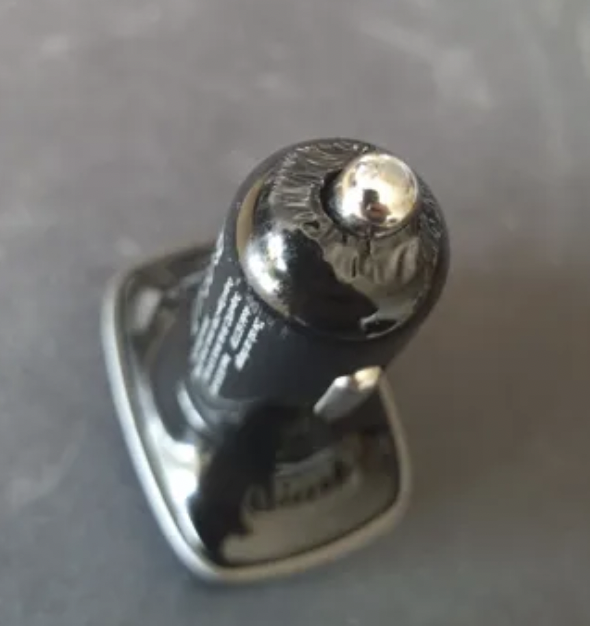
The 12V car adaptor charger did not like continuous use in the hot African climate.
3. Regulations may change at a moment’s notice. Check in advance and be prepared to submit / alter any submission for flight permissions. In our case, a new application process needed to be followed with additional and unexpected steps (and costs), at relatively short notice.
4. The developed mobile phone and app worked well in context. The community workers were able to use it after a short training (1/2 hr) and the system captured the data reliably. There was no damage to any of the ruggedized smartphones and despite them getting hot from continued use and the warm weather, there were no breakdowns.
5. Drones are highly effective for aerial mapping and can be deployed and used reliably in remote areas without external infrastructure, as long as the project is carefully planned. Although the remote nature of the context for the field test forced us to bring everything that we would need with us, including a portable RTK unit, it all worked as planned and generated aerial mapping imagery for subsequent processing. The team did note the flight time achieved per battery charge was significantly shorter (25 mins only) than that in the UK (closer to 30-40 mins). This was put down to the higher temperature and intensive battery cycling (see point 2). This reduced the size of the area coverable on each flight, resulting in more flights to cover the same land area.
6. Local engagement is essential for successful drone implementation in communities. Kudos goes to TCS for their work with the Mansonia populace. However, we did identify opportunities for greater planting efficiency and forest density. These included optimising the overall layout for reduced manual movement across the land, positioning the saplings in row distances optimised for the specific species, clearing the land and marking the planting spots in advance of ‘planting day’.

Daniel Ronen of UAVaid with the planting teams and staff from TCS and CAiSL.
So What Was The Result ? Ask the Ministry of The Environment…
We were privileged to have with us for the Loma deployment, John Brima from the Government of Sierra Leone. As Assistant Director of Forest Research and Extension, Ministry of Environment and Climate Change, Forestry Division, he had a particular interest in the field trials and oversaw the project implementation, technology application and community engagement. So, what was his feedback…?
Next Steps
Based on the success of the field trial, the next sprint within this pilot will see the drone and smartphone data processed and fused together onto a cloud based platform, creating a single point of data representation to demonstrate the system as a viable verification standard for reforestation, accessible from any web browser in the world.
If you’d like to dig in further…
📚 Read about the drone’s first test and the top five learning points — “Drone Mapping UK Cornwall On The Way To Africa”
📚 Learn about the pilot’s efforts in determining data literacy —“Determining Digital Literacy for Reforestation in the Mansonia Community, Sierra Leone”
📚 Learn about the pilot’s recent planting event — “Transforming Sierra Leone’s Landscape: A Community Tree Planting Event Powered by Mobile App Geotagging”