
Sprint 4: FOLIA's Innovation Journey: From Farm Boundaries to Cloud-Based Infrastructure
A blog by Carlos Pedraza, a Frontier Tech Hub Implementing Partner, and Harry Sharp, a Frontier Tech Hub Coach.
This post describes the technical challenges associated with gathering accurate data about farm locations and boundaries and building FOLIA’s digital infrastructure from our pilot Integrating satellite and ground big data to improve cocoa production.
Our pilot has tested innovations aimed at improving the way cocoa businesses address deforestation risks and adhere to stringent EU regulations. Our solution, FOLIA, is a satellite and app-based system that supports smallholder cacao producers in Colombia to access new markets by increasing transparency in the value chain.
We believe FOLIA can help transform the traditional cacao value chain into a more transparent, robust, and zero deforestation-ready system, by addressing challenges of traceability, deforestation monitoring, and compliance.
In this blog, we discuss our approach to gathering information about farm locations and boundaries, and the impact of using the innovative Infrastructure-as-Code (IaC) model as the backbone of FOLIA.
Farm Location and Boundaries: A Crucial EU Due Diligence Requirement
One significant challenge in analyzing deforestation risks is how to gather accurate data about farm locations and boundaries. This data is needed for deforestation risk assessments at farm-level, which is a requirement to meet EU deforestation-free regulations when importing cocoa into the EU. Close collaboration with key stakeholders in the value chain, particularly producers and technical assistance teams, is critical to collecting this data.
To make this possible from a technical perspective, we partnered with the development team at GALAPP, a mobile application already widely adopted by the agricultural sector. Together, we integrated FOLIA with the user-friendly GALAPP app and introduced polygon surveying functionality. This enables producers and technical assistance teams to use their mobile devices to capture coordinate data to define farm locations and boundaries. Coordinates can be captured offline and uploaded to FOLIA once mobile signal is available. Once in FOLIA, each farm property’s coordinates are displayed as polygons on a map. The system then generates a deforestation risk assessment for each farm based on analysis of satellite data. We discussed this in more depth in our Sprint 3 blog.
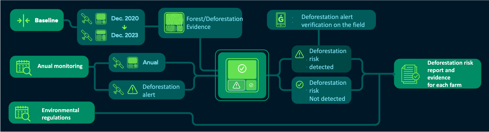
The following flow diagram describes how GALAPP provides functionality to generate farm locations or boundaries as input into FOLIA.

An alert is generated if a significant risk of deforestation is detected at a farm (approximately 85% of confidence). Additional information is required to validate whether deforestation has occurred or not. Producers and technical assistance teams can provide this information by visiting the alert site and uploading comments and geo-tagged photos. This complementary information is integrated to refine the deforestation risk assessment and reduce the risk of false positives, such as flooding events, being misinterpreted as deforestation.
The figure below shows how GALAPP integrates the verification data of the alerts.
Field Testing: Improving App Stability, User Experience, and Data Quality
Before releasing the app for testing by producers and technical field assistants, our product testing team from DreamGIS and GALAPP conducted extensive field testing to improve app stability, user experience, and data quality. The team collected locations and boundaries at a number of farms in Cundinamarca, Meta and Santander departments. Their feedback enabled our development and design teams to address bugs and inconsistencies. The results were encouraging. The app demonstrated robust performance in online and offline scenarios, even when dealing with hundreds of coordinates on large farms.
Whilst we celebrate these developments, we continue to enhance the user experience by simplifying user tasks, especially those regarding the polygon generation.
The figure below shows the GALAPP app with waypoints marking boundaries.

Building the Digital Infrastructure: The Backbone of FOLIA
Our development team has created a digital infrastructure to underpin the entire FOLIA system. This cloud-based infrastructure stores farm boundaries, processes imagery for deforestation risk assessment, and houses all the information required for Zero Deforestation Due Diligence.
We knew the conventional approach to developing and managing infrastructure manually would not be viable for us to scale the pilot solution. It can quickly result in inconsistencies, human errors, and time-consuming processes. It was important for us to consider this from the outset or risk having to make fundamental changes down the line. We needed to develop a systematic and automated approach using code-based scripts.
Our team decided to deploy the Infrastructure-as-Code (IaC) model, which offers improved efficiency, repeatability, and scalability. It’s helping our team to collaborate more effectively with version-controlled changes to the solution’s infrastructure that reduces the risk of ‘configuration drift’. It’s a more agile approach that allows us to better respond to changing requirements as we develop and scale FOLIA’s underlying infrastructure. We believe this approach has saved our team a significant number of hours of development in the last 2 months, reducing deployment and maintenance time by around 60% (approximately from 120 hours to 72 hours).
Deploying IaC has not been without its challenges. We have had to overcome a steep learning curve with new programming languages and tools, rigorous testing processes, and extended development times. However, the benefits of IaC are important to scaling our solution in the long term, and it has been important to invest time and energy to overcome these challenges during this sprint.
Our journey with FOLIA continues to be one of innovation and a commitment enabling smallholder cacao producers to have better access to new markets whilst protecting standing rainforests. As we navigate the complexities of technology, our vision for a more sustainable and ethical world remains unwavering.
The Next Steps: Pioneering the Future with FOLIA
As we look ahead to the future, our journey with FOLIA continues to evolve and expand, guided by our pilot’s North Star: generating increased market access to Colombian cocoa and supporting cocoa farming as a viable and desirable business for smallholder cacao producers in Colombia.
In the near term, we aim to deliver the first operational version of FOLIA with deforestation risk assessment functionality. This version will enable buyers to access key data and deforestation reporting capabilities related to the cacao producers from whom they purchase cacao.
We’re also excited to move from the realm of the cloud and satellites to cacao farms themselves. In this next phase we’re planning field training and testing with producers and technical field assistants to validate the feasibility of these users collecting cacao farm boundaries using our mobile app.
If you’d like to discuss this pilot or have any questions please contact:
Earth Big Data: carlos@earthbigdata.com
Frontier Tech Hub: harry@hellobrink.co
If you’d like to dig in further…
📚 Explore the pilot’s profile page
👀 You can also learn about this pilot through an interview with our Pioneer, Pedro Castro